A site team needs topographic data before design can move forward. The developer wants it fast, the engineer wants it accurate, and the project manager wants to avoid paying twice for the same deliverable. That is usually where the question of drone mapping vs surveying starts – not as a technical debate, but as a commercial one.
For property, construction, infrastructure, and industrial projects, the right choice depends on what decision the data needs to support. Drone mapping can cover large areas quickly and produce highly useful visual and spatial outputs. Traditional surveying provides the legal, control, and precision framework that many projects still require. The smartest approach is often not one or the other, but understanding where each method creates value.
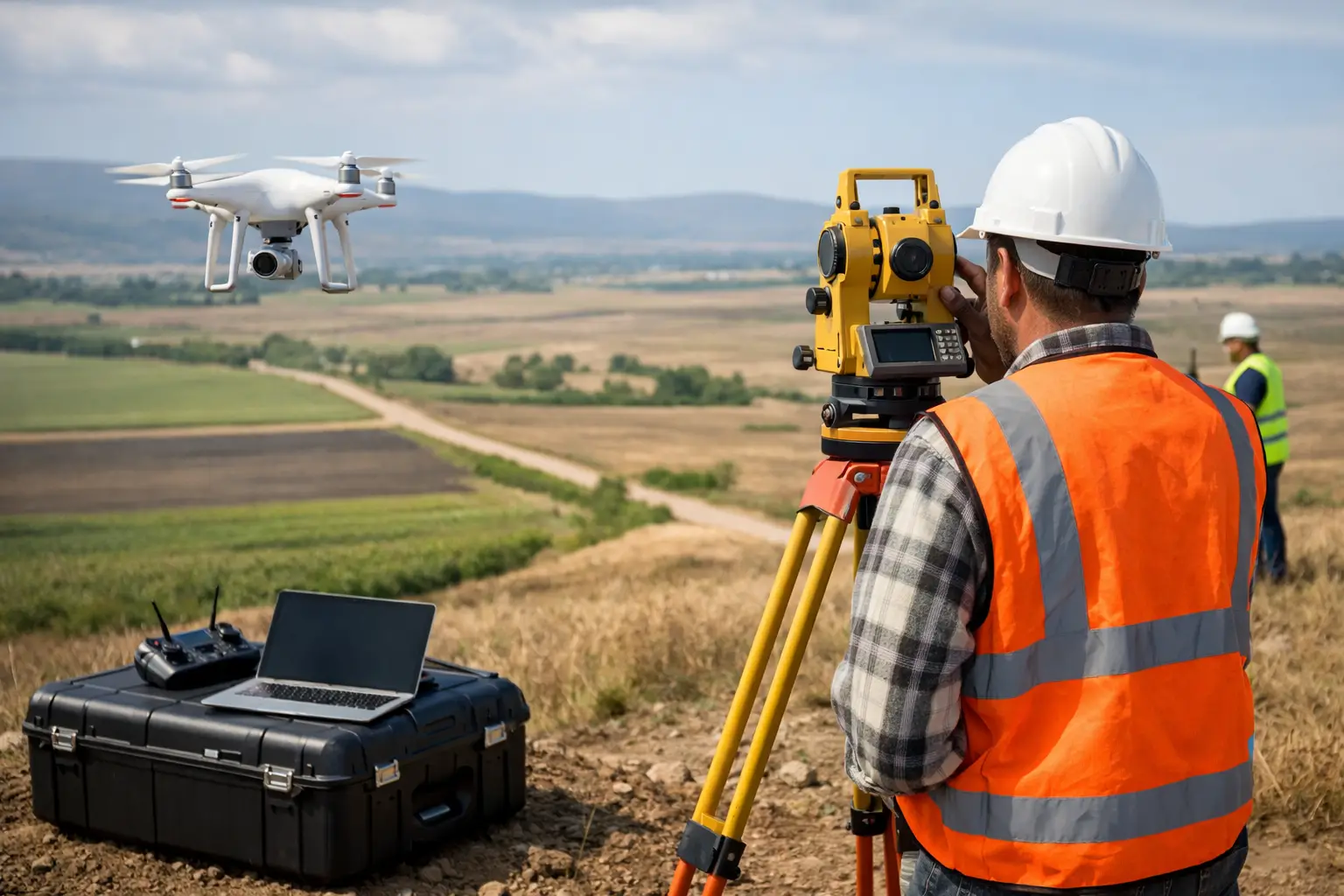
Drone mapping vs surveying: the real difference
At a high level, drone mapping uses UAVs equipped with cameras, LiDAR, or both to capture spatial data from above. That data is processed into outputs such as orthomosaics, point clouds, digital surface models, terrain models, and volumetric calculations. It is efficient, scalable, and especially effective for broad site visibility.
Surveying, in the conventional sense, relies on total stations, GNSS receivers, levels, and field-based measurement workflows to establish exact positions, boundaries, elevations, and control points. It is the backbone of legal boundaries, engineering setout, and high-precision documentation.
So when clients compare drone mapping vs surveying, they are often comparing speed and coverage against control and precision. That comparison is useful, but incomplete. The better question is this: what level of certainty is required, and what will the data be used for after capture?
Where drone mapping performs best
Drone mapping is strongest when a project needs fast, repeatable visibility across a large or difficult-to-access area. On construction sites, that can mean progress tracking, cut-and-fill measurement, stockpile volume estimation, and site condition monitoring. In real estate and industrial environments, it can support planning, marketing, asset visualization, and digital documentation.
One reason drone mapping has become central to spatial workflows is that it creates more than a drawing. It creates a visual record of the site at a point in time. That matters when multiple stakeholders need to review conditions remotely, compare progress over time, or coordinate across teams without repeated site visits.
For large developments, infrastructure corridors, quarries, plantations, industrial yards, and logistics facilities, the time advantage is hard to ignore. A drone can capture an area in hours that would take much longer with ground-only methods. That speed can compress decision cycles and help teams act earlier on grading issues, material movement, access constraints, or drainage changes.
Drone mapping also fits naturally into digital twin and 3D documentation strategies. Aerial data becomes more valuable when it is combined with terrestrial LiDAR, 360 capture, or Scan-to-BIM workflows. Instead of treating the site as a flat map, organizations can build a richer digital asset that supports design coordination, operations, reporting, and stakeholder communication.
The limits of drone mapping
Drone mapping is not a shortcut around precision requirements. Accuracy depends on flight planning, sensor quality, environmental conditions, processing methodology, and ground control. If the deliverable must support legal boundaries, title matters, or exact engineering setout, drone-only capture is often not enough.
Vegetation, reflective surfaces, weather, and obstructed terrain can also affect results. A photogrammetry-based drone mission may struggle in dense canopy or where the ground surface is difficult to see. LiDAR can improve ground penetration and geometric capture, but it also changes project cost and processing requirements.
That is why experienced providers do not position drone mapping as a replacement for all survey work. They position it as a method that is highly effective when aligned to the right outcome.
Where traditional surveying remains essential
Surveying still holds its place because many project decisions depend on defensible measurement, not just useful measurement. Boundary surveys, cadastral work, control networks, engineering stakeout, and compliance-sensitive deliverables require rigorous field procedures and established standards.
If a consultant needs certified levels for structural work, or a property transaction depends on exact boundary definition, traditional surveying is the safer and often necessary path. It is also critical for establishing the control framework that makes drone mapping more reliable in the first place.
This is where commercial decision-makers can make costly mistakes. If the brief is vague, teams may commission fast aerial capture for a task that actually needs survey-grade control and certification. The result is rework, delay, and avoidable duplication. A cheaper first step becomes a more expensive project.
Surveying has trade-offs too
Ground surveying is highly accurate, but it can be slower, more labor-intensive, and less practical across extensive or hazardous terrain. It also tends to produce more targeted measurements rather than full-area visual context unless paired with broader capture methods.
That matters when executive stakeholders, investors, or remote teams need an intuitive understanding of the site. Coordinates and linework are essential for technical delivery, but they do not always communicate conditions clearly to non-technical decision-makers. In those cases, drone outputs often improve alignment because people can see the site, not just interpret it.
Accuracy, speed, and cost: what actually matters
Most comparisons between drone mapping vs surveying focus on three variables: accuracy, speed, and cost. All three matter, but none should be looked at in isolation.
Accuracy should be measured against purpose. A project does not need the highest possible precision if the intended use is early-stage planning, progress reporting, or volume tracking at a practical tolerance. On the other hand, if errors could affect design geometry, legal compliance, or construction execution, tolerance becomes non-negotiable.
Speed matters because delayed site intelligence slows everything else. Aerial capture can help teams move faster, especially where site conditions change weekly. That is valuable in active construction, mining, industrial expansion, and large property development.
Cost is where many buying decisions become too narrow. Drone mapping may lower field time and improve coverage, but the real value is often in downstream efficiency – fewer repeat visits, clearer stakeholder reporting, earlier issue detection, and better integration into digital workflows. Traditional surveying may cost more for certain scopes, but it protects against failure where precision and defensibility are essential.
A better way to evaluate cost is to ask what a wrong or incomplete dataset would cost later.
When a hybrid workflow makes more sense
In many commercial projects, the most effective answer to drone mapping vs surveying is both. Survey control on the ground can establish the positional accuracy required for the project, while drone capture can scale that intelligence across the full site.
This hybrid model works especially well in AEC, industrial, and large-asset environments. Ground survey establishes control points, benchmarks, and critical measurements. Drone mapping then captures broad conditions, topography, stockpiles, access routes, roof areas, façade context, and change over time. When paired correctly, each method strengthens the other.
That approach also supports better data continuity. Instead of collecting information in disconnected formats, teams can build an integrated spatial record that is easier to use for BIM coordination, progress validation, facility planning, and stakeholder review.
For organizations moving toward digital twins or more advanced spatial asset management, this matters. The goal is not simply to capture a site once. It is to create a data foundation that remains useful across marketing, design, construction, operations, and maintenance.
How to choose the right method for your project
Start with the deliverable, not the tool. If you need legal boundary definition, engineering setout, or certified control, surveying should lead the workflow. If you need large-area visibility, frequent updates, volume analysis, or visual site intelligence, drone mapping is often the more efficient method.
Then consider site scale and access. Large sites, elevated assets, active work zones, and hard-to-reach terrain often favor drone capture because of speed and safety. Smaller, detail-critical scopes may lean more heavily on field survey methods.
Finally, think beyond the immediate task. If the data will later feed design models, digital twins, marketing assets, investor reporting, or facility operations, the capture strategy should support that broader lifecycle. This is where a specialist partner adds value – not by selling a single method, but by aligning capture with business outcomes.
Novo Reperio approaches this as a spatial data strategy, not a one-off service decision. That distinction matters when the objective is faster decisions, stronger documentation, and better visibility across complex physical environments.
The practical question is not whether drone mapping will replace surveying. It is whether your project is using the right level of spatial intelligence for the decision in front of you. When that answer is clear, the technology choice becomes much simpler.