A renovation stalls for a simple reason more often than most teams expect: the drawings do not match the building. A wall sits 300 millimeters off line, mechanical routes were changed during construction, or equipment was replaced years ago without formal updates. That is exactly where the question what is as built documentation becomes commercially significant. It is not just a record set. It is the verified picture of what was actually constructed, installed, and left in place.
For owners, developers, contractors, and facility teams, that distinction matters because decisions are only as good as the information behind them. If your plans reflect design intent but not field reality, every downstream task becomes slower, riskier, and more expensive.
What is as built documentation?
As built documentation is the final record of a space, asset, or building as it exists after construction, installation, or renovation. It captures the real-world dimensions, layouts, systems, and modifications that differ from the original design set.
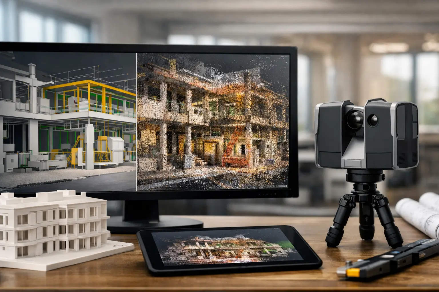
That can include updated floor plans, reflected ceiling plans, elevations, sections, equipment schedules, MEP layouts, BIM models, point clouds, and annotated records of changes made on site. In a modern workflow, it may also include LiDAR scans, 3D spatial data, and digital twin environments that allow teams to inspect conditions remotely.
The key point is simple: as built documentation reflects reality, not intent.
Why as built documentation matters in practice
The value of as built documentation shows up when a team needs to act quickly and avoid guesswork. A property owner planning a retrofit needs reliable dimensions. A hotel operator upgrading guest floors wants to minimize disruption. A factory manager scheduling maintenance needs to know where systems actually run, not where they were supposed to run.
Without accurate as built records, teams often rely on site revisits, manual measurements, fragmented PDFs, and institutional memory from people who may no longer be involved. That creates delays and exposes the project to rework, coordination issues, and cost overruns.
With accurate documentation, the opposite happens. Design teams work from verified information. Contractors price more confidently. Facilities teams locate assets faster. Stakeholders review spaces remotely and make decisions with fewer surprises.
This is why as built documentation is not only relevant to architects and engineers. It has direct value for commercial real estate, hospitality, industrial operations, insurance assessment, and portfolio management.
What is included in as built documentation
The exact deliverables depend on the project, but most as built packages include a combination of measured drawings and verified site data.
At a basic level, this usually means updated plans that reflect actual room sizes, wall locations, door and window positions, and installed building elements. For more technical projects, documentation may extend to structural components, mechanical and electrical systems, plumbing runs, plant equipment, and ceiling coordination.
In more advanced workflows, as built documentation also includes point cloud data from LiDAR scanning, a 3D model derived through Scan-to-BIM, and sometimes a navigable digital twin. That combination gives teams both documentation and spatial context. You are not only reading dimensions on a sheet. You are reviewing the space as a data-rich asset that can support planning, coordination, and ongoing operations.
That matters because different stakeholders consume information differently. A designer may need a BIM model. A facility manager may prefer a virtual walkthrough. A commercial decision-maker may need both, because faster approvals and clearer stakeholder communication have real business value.
As built drawings vs original drawings
This is where confusion often starts. Original drawings show what the project was intended to become. As built drawings show what was actually delivered.
Those two versions are often close, but not always. Site conditions, material substitutions, coordination clashes, contractor adjustments, tenant requests, and late-stage engineering changes can all alter the finished result. Even small deviations become important when they affect fit-out work, equipment installation, accessibility, or maintenance access.
A common mistake is assuming a construction drawing set is good enough for future use. Sometimes it is. Often it is not. If the building has gone through multiple contractors, phased upgrades, or years of undocumented changes, the gap between paper and reality can be substantial.
How as built documentation is created today
Traditional as built documentation relied heavily on manual redlines, tape measurements, and field verification. That method still exists, but it is slower and far more vulnerable to omissions, especially on large or complex sites.
Today, many projects use LiDAR scanning and 3D capture to document conditions quickly and with a much higher degree of consistency. A scanner captures millions of spatial data points across the environment, creating a detailed point cloud that reflects the actual geometry of the site. From there, teams can generate measured drawings, create BIM models, and validate dimensions without repeated site visits.
This approach is especially useful for occupied buildings, large facilities, heritage properties, and renovation projects where hidden complexity is common. It also improves collaboration because multiple consultants can reference the same verified dataset.
For decision-makers, the commercial upside is straightforward. Better source data reduces design uncertainty, improves coordination, and helps teams move from site capture to planning faster.
When you need as built documentation most
Some projects can operate with limited records for a while. Others cannot. The need becomes more urgent when the cost of inaccuracy is high.
Renovation and retrofit projects are an obvious example. If new systems must fit around existing conditions, poor documentation creates immediate coordination problems. The same applies to adaptive reuse, interior fit-outs, MEP upgrades, and space reconfiguration.
It is also highly valuable during asset handover, facility management onboarding, insurance documentation, dispute support, and pre-acquisition due diligence. In those scenarios, as built documentation is not just helping design. It is reducing uncertainty around the asset itself.
For organizations managing multiple sites, standardized as built records also improve portfolio visibility. Instead of relying on inconsistent legacy documents, teams can work from a clear and current spatial baseline.
The business case behind accurate documentation
As built documentation can look like a technical deliverable, but the return is operational and financial. Better records reduce wasted site time, improve procurement accuracy, and lower the chance of rework. They also help teams sequence work more effectively, especially when timelines are tight and disruption must be controlled.
There is also a communication benefit that is easy to underestimate. Clear documentation shortens the distance between technical teams and commercial stakeholders. When everyone can see the same verified conditions, approvals move faster and project risk becomes easier to explain.
That is particularly relevant in sectors where remote decision-making matters. Investors, operators, consultants, and regional teams are often not in the same place. A documentation set supported by 3D spatial capture or a digital twin gives those groups a far more reliable basis for review than static photos or outdated PDFs.
What good as built documentation should deliver
Not every record set provides the same value. The best as built documentation is accurate, current, and usable by the teams that need it. That sounds obvious, but usability is often where documentation falls short.
If files are incomplete, hard to interpret, or disconnected from operational workflows, their value drops quickly. On the other hand, when records are structured around real use cases such as renovation planning, facilities coordination, stakeholder review, or BIM integration, they support decisions long after the original capture is complete.
It also depends on project scope. A small tenant fit-out may only need verified 2D drawings. A hospital, hotel, plant, or mixed-use development may benefit far more from a Scan-to-BIM process backed by LiDAR data. The right level of documentation is the one that matches the complexity and commercial importance of the asset.
What is as built documentation in a digital-first environment?
In a digital-first environment, as built documentation is no longer just an archive. It becomes part of the operating layer of the asset. The same verified spatial data can support renovation planning, virtual inspections, remote stakeholder engagement, maintenance coordination, marketing visualization, and long-term digital asset management.
That shift matters because buildings are no longer managed only on site. They are reviewed, sold, upgraded, insured, and optimized across distributed teams. Accurate as built records make that possible with fewer assumptions.
For companies investing in digital twins, LiDAR mapping, or Scan-to-BIM workflows, as built documentation is often the foundation that makes those systems useful. Without verified existing conditions, even the best digital tools are working from incomplete inputs.
If you are evaluating a property, planning a retrofit, or trying to manage a complex facility with greater confidence, start with the question behind the question: not just what is as built documentation, but what will inaccurate records cost you over the next decision cycle.